Contents
Have you ever thought why some places on Earth are still no-fly zones, even with all our modern technology? Despite how far air travel has come, there are areas where planes dare not fly.
Asking questions always sparks interest. When I thought about how nature influences where we can fly, I found three places where flying is nearly impossible. Everyone knows about the Bermuda Triangle, a spot famous for strange disappearances. But, one such place in Asia. Yes, Asia has its own version of this mystery. It is called the “Tibetan Plateau,” and it’s just as dangerous.
The World’s Most Dangerous Flight Zones & Historic Data
| Attributes | Tibet (Mount Kailash and Himalayas) | Bermuda Triangle | Antarctica |
| First Plane Loss Year | 1942 | 1945 (Flight 19) | 1979 (Air New Zealand Flight 901) |
| Plane Type | Military (Curtiss C-46) | Military (Flight 19) | Public (Tourist Flight) |
| Flight Belonged to | India/Nepal | United States | New Zealand |
| Purpose of Travel | Exploration/Military & Local Transport | Military Training | Sightseeing |
| Casualties in First Incident | 4 | 14 | 257 |
| Travel Ban Imposed Year | 1950s | Not officially imposed | 1979 |
| Authority Imposing Ban | Local Governments (India, China) | Avoided by some countries unofficially | New Zealand Government |
| Total Flights Lost to Date | Possibly 454 | 20 | 1 |
| Total Casualties to Date | More than 2,000 deaths have occurred in the region since World War II | More than 1,000 are estimated | 257 |
| Most Recent Plane Loss Year | 2023 | 2017 | 1979 |
| Casualties in Last Incident | 68 | 4 | 257 |
| Survivability | Minimal | Extremely rare | None in the single recorded crash |
This mysterious area lies over the Tibetan plateau. Its severe conditions have made it one of the most difficult places for planes to cross. Like the Bermuda Triangle, it has a chilling history of challenges for pilots.
How Was the Tibetan Zone a Mystical Region for Britain During World War II? – The Historical Background
To understand why planes, avoid the Tibetan Plateau, we need to go back to World War II.
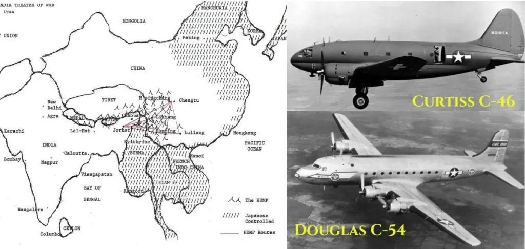
During the war, Japan was a dominant force, and Britain’s colonizers at the time, sided with China. Britain and America needed to send weapons to help China fight against Japan, but how? So, they decided to use air routes over what is now Assam in Eastern India, flying across the Tibetan Plateau.
At first, this seemed like a great plan. The route, nicknamed “The Hump,” was only 840 kilometers a relatively short distance by air. But as planes started flying this way, the America soon realized the wrong.
The Hump Airlift Area and the Fighter Jets mostly Used

During the war, more than 700 planes attempted to cross this region over 42 months, but 590 disappeared without explanation. Along with the planes, 1,659 people also vanished. The losses in this area were so severe that they surpassed the number of planes shot down during the war.
Eventually, this air route was abandoned, and the region became a no-fly zone. The unknown didn’t stop with World War II. Even today, planes avoid the Tibetan Plateau. (Ref)
Understanding the Location – Insights Into the Roof of the World
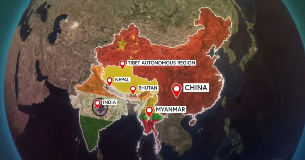
Tibet, part of China, is located in the southwestern region of the country. It sits on the Tibetan Plateau, bordered by the Himalayas to the south, India and Nepal to the west, and Bhutan to the southeast.

For your understanding: the scale of the Tibetan Plateau covers an area 5 times larger than France. Despite its size, it is home to only about 14 million people, an unexpectedly small number compared to the population density of the rest of China, The population density here is less than 13% of China’s average.
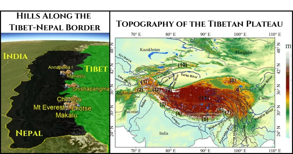
So, you may be confused: Why do so few people live in such a large area? The answer lies in the region’s extreme environment. The Tibetan Plateau sits at an average altitude of 14,000 or 4,380M feet above sea level, making it the most elevated place on Earth. This extreme elevation gives it its nickname “The Roof of the World.” And, Living here is challenging because of the extreme climate. The geography of this region is unique and challenging. It is surrounded by elevated mountains, including most of the highest peaks in the world.
List of the World’s Highest Mountains Located Over the Tibetan Plateau
| Mountain Name | World Rank | Height (ft) | State/Region | Country |
| Mount Everest | 1 | 29,032 | Tibet/Nepal | China/Nepal |
| Lhotse | 4 | 27,940 | Tibet/Nepal | China/Nepal |
| Makalu | 5 | 27,766 | Tibet/Nepal | China/Nepal |
| Cho Oyu | 6 | 26,906 | Tibet/Nepal | China/Nepal |
| Shishapangma | 14 | 26,289 | Tibet | China |
| Manaslu | 8 | 26,781 | Gandaki Province | Nepal |
| Annapurna I | 10 | 26,545 | Gandaki Province | Nepal |

5 Reasons Why Planes Don’t Fly Over the Tibetan Plateau
The Tibetan Plateau is considered a highly dangerous region for flights due to a combination of natural challenges and socio-economic factors.
Here are the five main reasons Tibet became a no-fly zone
1. Geographical Extent of the Tibetan Plateau
The Tibetan Plateau is the largest plateau on Earth, spanning an impressive 2.5 million square kilometres. Its dimensions stretch approximately 1,000 kilometres from north to south and 2,500 kilometres from west to east. This vast expanse includes several major mountain ranges, such as the Himalayas, which house Mount Everest, the tallest mountain in the world. With an elevation of 8,848.86 meters, Mount Everest nearly matches the cruising altitude of commercial aeroplanes, stressing the unique challenges posed by this region’s topography.
2. Airport Distances and Infrastructure Challenges
The region’s sparse infrastructure adds to the challenges of flying over the Tibetan Plateau. For instance, the Nyingchi Mainling Airport, located in eastern Tibet, is located far from other major airports. The closest significant airport, Lhasa Gonggar Airport in Tibet’s capital, is approximately 1,100 kilometres away. This vast distance exemplifies the logistical difficulties of managing emergencies, as landing options are extremely limited compared to more developed areas. The lack of closely connected airports significantly complicates emergency response efforts in this remote area.
3. Height Comparisons and Altitude Constraints
The Tibetan Plateau’s average elevation of 4,500 meters creates a unique obstacle for aviation. In emergencies, aeroplanes typically descend to lower altitudes, such as 3,000 meters, to stabilize conditions like air pressure. However, the plateau’s elevation exceeds this safe descent range, leaving aircraft with little room to manoeuvre. Additionally, towering mountain peaks such as Mount Everest and others in the Himalayas further limit altitude flexibility, making safe navigation particularly challenging.
4. Geographical Isolation and Political Restrictions
The Tibetan Plateau’s remote nature makes it one of the most geographically isolated regions in the world. This isolation is exacerbated by political restrictions imposed by the Chinese government, particularly in areas near the borders with Nepal and India. These restrictions often designate vast no-fly zones, requiring aeroplanes to take longer, less efficient routes. Such limitations complicate air navigation, as airlines must adhere to strict regulations while dealing with the already challenging topography and weather conditions.
5. Weather and Environmental Conditions
The Tibetan Plateau experiences extreme weather conditions that further complicate aviation. Winter temperatures often plummet to -40°C, presenting risks like jet fuel freezing, which can severely impact aircraft operations. The thin air at high altitudes reduces lift efficiency, forcing aeroplanes to fly faster to maintain altitude. This increased speed strains aircraft systems, particularly over a region with limited emergency support facilities. These harsh environmental factors, coupled with the challenges of high altitude and sparse infrastructure, make the Tibetan Plateau one of the least favourable regions for aviation.
Current Situation of Tibet’s No-Fly Zone: Why Flights Still Avoid This Region
Even today, the Tibetan Plateau, remains a no-fly zone for most commercial airplanes. The Chinese government imposes strict limitations on flights over and within Tibet, citing both safety and political concerns.
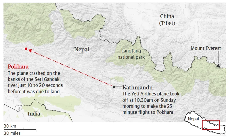
The Most Recent Flight Accident in the Tibet’s Region & Travel Path

From a logistical view, Tibet lacks modern navigation systems such as Global Positioning Systems (GPS), short range radio systems (VOR), and Instrument Landing Systems (ILS), making it difficult for pilots to navigate or maintain safe altitudes. These gaps in infrastructure, combined with Tibet’s extreme geography, extreme weather conditions, high altitude, and limited emergency landing options, pose notable risks for air travel. Jet fuel freezing at extreme altitudes additionally adds to the challenges.
Commercial flights to and from Tibet are limited. There are a small number of weekly flights, such as routes from Kathmandu in Nepal to Lhasa and approximately 35 flights per week from various cities in China to Tibetan airports. Additionally, between 40 and 100 flights operate weekly between Tibet’s five airports. However, overflights by international commercial aircraft are rare and permitted only under exceptional circumstances.
Given these challenges, flying over Tibet remains a rarity, and its airspace continues to be one of the most regulated in the world.
So, The Tibetan Plateau, or “The Roof of the World,” reminds us that nature still holds power over human advancements. While we have dominated the skies and aim of populating further planets, regions like this remain beyond our reach due to natural challenges we can’t easily overcome.
Here, you can find China’s Recent Incredible Gold Discovery That Could Transform the World by 2030.
